Effects of recent rainfalls on the Rio Enzola stream
Flooding and flash floods on the rivers and streams that flow into the anthropized territories has become particularly important for cities and smaller urban centers, which are increasingly exposed to both events related to prolonged rainy periods, such that events related to sudden rains and very intense.
The Quattro Castella area is characterized by the presence, in the hilly portion, of small basins with often clayey soils, which collect and concentrated water along the drainage axis of the valley, where the streambeds are engraved and wide 1-2 meters, with limited space to accommodate floods.
At the outlet downstream of these small streams almost immediately meet the foothills of the villages and, in short, are confined or piped.
An example of this situation is represented by the Rio Enzola stream, that generated at harvest in a hilly basin flowing with torrential regime, then travels less than 1 km in the plains in a river bed not dammed, before crossing the urban area of the town. (video of streambed flood).
The streambed becomes dammed roof (*) and then through the industrial area of Quattro Castella and Bibbiano, then take in the creek Crostolo.
In this context, even the rains of the last period can generate a potential risk.
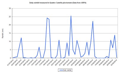
The data measured by the ARPA pluviometer in Quattro Castella hills show a number of rainfall events with daily precipitation peaks around 20-25 mm per day, certainly completely ordinary events.

Rainfall in January and February 2014
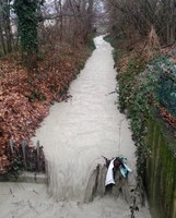
However, these rains have helped swell the river noticeably, as it was found during a joint survey between technicians of the municipality, Land Reclamation Consortium and project engeneers, made over the course of the streambed.
Some pictures taken during the survey, are available here.
In the multimedia section of the site, it is also possible to see the "real" situation in a video specially made.
(*) A channel is defined as "roof" when it is at a topographic altitude higher than the surrounding areas.

